
Warm walks, so much history and a city with a feeling of its own. My time in Syracuse, and the architecture project that followed me home.
Some places stay with you because of one particular building or one very specific moment. With Syracuse, it was the feeling of the city as a whole.
I loved the warm walks while we explored, and how much history there was to discover. Later, back at my desk, I was still working through the city in drawings and research. So this is a little bit of both: the trip and the master’s project that came with it.
QUICK TAKE
Syracuse was warm walks, beautiful details and so much history to discover. Then it became maps, sketches and an urban atlas for my architecture master’s. The city stayed with me in more ways than one.
First Impressions: That Syracuse Feeling
The thing I remember most about Syracuse is the feeling of being there. The warm walks while we explored the city, the buildings around us and the sense that there was always more history to discover. Every city has its own atmosphere, and Syracuse definitely had one of its own.
You know when you try to explain a place to someone and end up saying, “It just had such a nice vibe”? That is honestly where I would start. Which probably sounds slightly funny coming from someone who then spent so much time analysing its architecture. But the feeling came first. Understanding what might be behind it came afterwards.

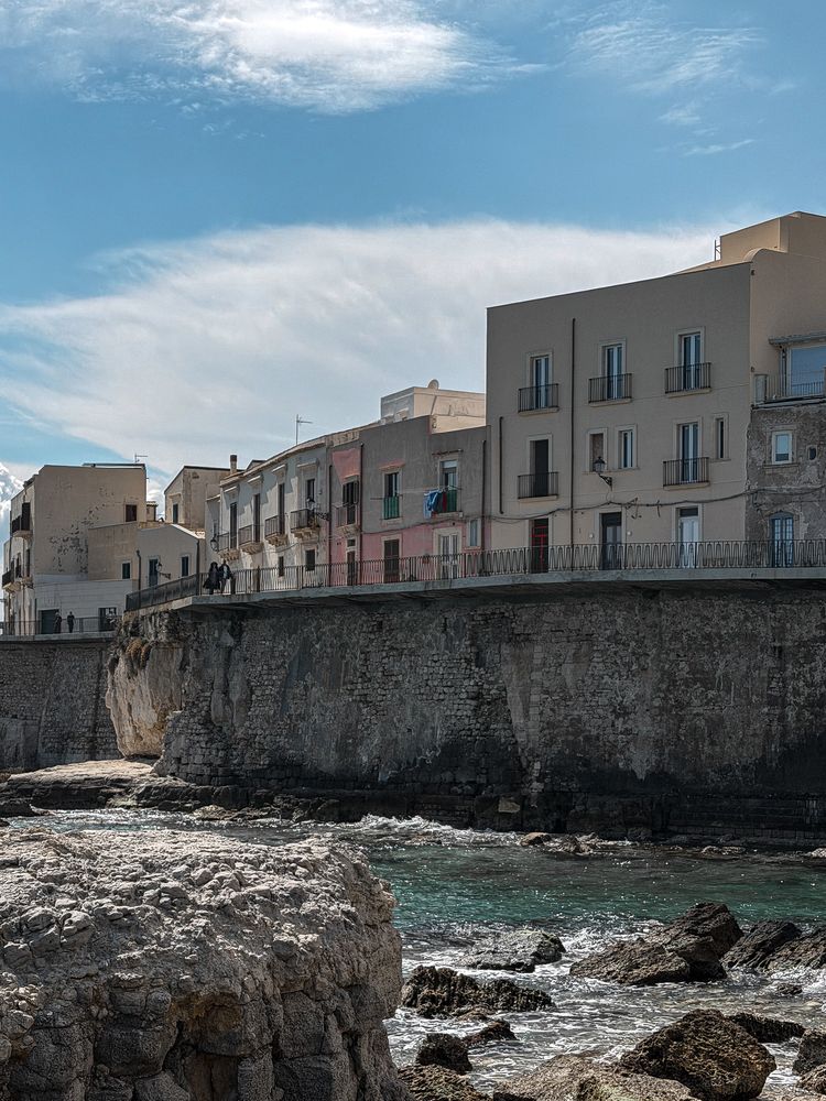
Looking through my photos brings me back to that contrast. There is the sea and the open sky, then a narrow street with balconies above it. A heavy stone edge along the water, then ordinary houses with shutters, plants and washing outside. Some views feel quite grand. Others are just little pieces of everyday life.
I like having both in my photos. The impressive buildings deserve attention, obviously, but I would not want the smaller moments to disappear from the story. They are part of what makes a city feel like somewhere people actually live. And for me, that was a big part of Syracuse’s appeal.
A Trip That Followed Me Back to My Desk

Syracuse also became part of my architecture master’s work. Before designing, we had to understand the city: its history, buildings, public spaces, infrastructure and how those things had developed together. There was quite a lot behind that apparently simple instruction.
Our work brought together research, drawings and maps in an urban atlas. Historical maps, books, archives and existing studies helped us build a clearer picture. We also looked at building types, façades, materials, demographics, mobility and the relationships between buildings and public space.
So the photographs of my desk belong in this post just as much as the photographs from Sicily. The sketchbook, the open guide, the plans covered in corrections and the drawings on the screen are all part of the same project. Different surroundings, same city still taking up space in my head.
Months later, we were still revisiting the atlas for its final corrections. There is something very familiar about a university project that looks almost finished while still having a surprisingly long list of details left. Apparently, returning from the trip did not mean I was done with Syracuse.
What I like about that is how the experience keeps changing. A place you first know through walking becomes a photograph, then a drawing, then something you need to explain clearly on a page. Each version makes you notice something slightly different.
A Little History, Because There Is a Lot Here
First, the names: Syracuse in English, Siracusa in Italian and Syrakus in German. Ortigia is its historic island centre, rather than the whole of the present-day city. Keeping that distinction in mind helps when looking at maps or reading about different parts of the place.
Greek settlers from Corinth founded Syracuse in the eighth century BC. Roman, Byzantine, Arab and Norman periods, among others, contributed further layers to its history. In 2005, Syracuse and the Rocky Necropolis of Pantalica became a UNESCO World Heritage property. Pantalica is a separate location outside the city. Historical reference: UNESCO.
That is the short version. What interests me is how much of a city’s past can remain present without being immediately obvious. A reused structure, a change in a wall or the shape of a street can lead to a much bigger question than the photograph originally suggested.
I do not need to memorise every date to enjoy a place. But having some context makes me look again. Suddenly, something that seemed like a small architectural detail belongs to a longer story. Syracuse was full of that possibility, and I loved knowing there was so much more to discover.
For the atlas, of course, “this looks old” was not quite enough. That is where the research came back in. The interesting interpretation still needed something solid behind it.
The Streets Between the Highlights
One of my photographs shows a street corner with older houses next to a taller apartment building. There are parked cars, overhead wires, shutters and different balcony railings. It is not the sort of view that neatly sums up a destination on a postcard. I still wanted to include it.
When we talk about a city’s character, it is easy to reach for its most recognisable monuments. But the streets connecting those places matter too. They give you the changes in scale, the everyday details and the transitions that make walking through a city feel different from looking at a collection of individual buildings.

That is what I find interesting in this image: the buildings do not all match, yet they share the same corner. Their heights, openings and surfaces sit next to one another. The road and pavement connect them into a scene that feels much more complicated than a single façade.
During a warm walk, you experience all of that without necessarily naming it. You turn a corner, the view changes and your attention moves somewhere else. Later, looking at the photograph, you can slow that moment down.
I think that is one reason travel and architecture fit together so naturally for me. Enjoying the atmosphere and being curious about how it works can happen at the same time. You do not have to turn every walk into homework. Although, in this case, some homework was involved.
The Little Details: Balconies, Stone and Shadows

The pink façade in my photographs is exactly the kind of image I can keep looking at. There is the rhythm of the balconies, the metalwork and those substantial carved stone supports underneath. Then the plants interrupt the repetition, and a streetlight adds another layer in front.
My attention goes back and forth between the whole building and the individual pieces. From a distance, the façade has an order. Closer up, there is much more going on: the edges of the openings, the shutters, the projecting balconies and the texture of the surfaces.
This is where drawing and architectural analysis start to make sense to me. A façade is not actually flat, even when we draw it as an elevation. It has depth. Things project, things sit further back, and those small differences change the shadows and the relationship to the street.
At the same time, I would be careful about assigning a date or a style from a decorative detail alone. A lovely balcony does not come with its own complete building history. Looking closely is the beginning of that process, and research helps with the next step.
But as a travel moment? Sometimes I just want to enjoy how good all those details look together. I can be interested in the construction and still be very easily distracted by a pretty façade. Both things are true.
A Cathedral With More Than One Life
Syracuse Cathedral is a particularly striking example of how different periods can exist within one building. On Piazza Duomo, the cathedral incorporates the Doric columns of the ancient Temple of Athena. Those ancient elements remain visible, while the Baroque façade belongs to a later stage in its history. Historical reference: Visit Sicily.
For me, this is where architectural history becomes much easier to connect with. You are not only reading about one building replacing another. Parts of an earlier structure continue within something that has changed in use, appearance and meaning.
It also brings up questions that are relevant far beyond Syracuse. What do we keep when we work with an existing building? What gets adapted? Which traces remain legible, and which become harder to recognise? Those are interesting questions to carry back into a design project.
I like the thought that a building can have several lives without all the earlier ones disappearing. It makes the word “existing” feel a little less straightforward. What already stands there is itself the result of previous decisions, changes and repairs.
That is one of the reasons the history of Syracuse belongs alongside the travel photographs in this post. Knowing a little more gives the architecture another dimension. The city becomes more than the version we happen to see at one particular moment.
And Then There Is the Sea
The photographs along the water have a completely different feeling from the narrow streets. There is more sky, more distance and a much clearer outline to the city. I love how strongly the buildings and the stone edges sit against the sea.
In the photograph of the waterfront houses, you can see several levels at once: the rocks and water below, the high stone wall, the path with its railing and the homes above. It is a beautiful view, but it is also a very clear architectural relationship.

If I were explaining that relationship in a drawing, a section would be useful. A plan can show the buildings beside the water. A section can show how far above it they sit and what happens between the different levels. This is the sort of thing that becomes much easier to understand when you switch drawings.
The other waterfront photograph looks towards Castello Maniace at the tip of Ortigia. The castle was built under Frederick II in the thirteenth century, between 1232 and 1240. Its position is part of its significance as a fortification. Historical reference: Regione Siciliana.
What stays with me in my own photograph is also the atmosphere: the clouds, the darker water and the long stone edge. It is a different side of the same place. That is something I really like about these images together.
Research, With Quite a Few Things Open at Once

The desk photographs are a fairly good explanation of what came afterwards. Books, a laptop, printed plans, the sketchbook and a drink somewhere in between. Looking at them, it is very clear that Syracuse had made the journey back with me.
Research helped connect the things we were looking at. A historical map could raise a question about a street. A book might provide context for a building. Existing studies gave us other ways of understanding the city, and our drawings had to bring that information into a form people could actually read.
One thing I find useful to remember is that different sources were made for different purposes. A simple overview map and a detailed survey are not doing the same job. If their lines differ, that does not automatically mean the city changed between the two.
The same care applies to the scale of a claim. Something written about one building does not necessarily explain an entire neighbourhood. It sounds obvious until you are trying to fit a lot of material together into one coherent set of pages.
That part takes patience. But I like how it changes the initial impression of a place. You start with something that caught your eye and gradually discover what you can actually say about it. Sometimes the answer is more interesting than expected. Sometimes it means going back and checking again.
Why I Still Wanted to Draw It
I already had photographs. I still had the sketchbook.
The drawing of the doorway shows why I like having both. The arch, the stone joints and the metalwork become a series of decisions when I draw them. Which lines matter? How wide is the opening compared with the wall around it? Where does the depth become visible?

A photograph lets me keep a lot of information at once. A sketch makes me choose what I am paying attention to. That does not automatically make it more accurate, but it does make the process different. I have to spend time with the thing I am trying to understand.
I also like that the page looks worked on. There are stronger lines, softer areas of colour and details that receive more attention than others. It feels like a record of looking, with all the little choices that come with that.
Of course, a sketch like this is not a measured survey. I would not pretend that every line provides an exact dimension. Its value is in the observation and the questions it helps me formulate.
If you enjoy looking at buildings, I think it is worth trying even without studying architecture. Pick a doorway or a window and draw a few lines. The result does not have to be impressive. Giving the detail a little more time is already a different way of experiencing it.
Turning a City Into an Atlas

Making an urban atlas involves quite a lot of choosing. We looked at demographics, mobility, public space, historical layers and urban structure. Those subjects relate to one another, but putting all of them on one page would not necessarily make the city easier to understand.
For me, the helpful question is: what is this drawing actually trying to explain? A map of public spaces has a different purpose from one showing movement and connections. A historical comparison needs a different kind of information again.
The graphic decisions follow from that. Scale, line weight, colour and legends affect what the reader notices first. A drawing can look very convincing while still leaving its main question unclear. Making the pages visually consistent matters, but the information needs to hold together too.
There is also a difference between an observation and a general conclusion. A quiet square in one photograph does not tell us how busy it is throughout the week. A demographic map needs its source and reference year. These details are part of making the work useful.
I think that is what makes an atlas interesting as a university project. It asks you to move between the experience of the place and the responsibility of representing it. You cannot include everything. You have to decide what helps explain the city and make that selection understandable to someone who was not there with you.
What the Plans Showed Differently
The screen photographs show plans alongside building elevations. I like that combination because they answer different questions. The elevation gives you the outward arrangement of a building. The plan shows how it sits among streets, neighbouring buildings and courtyards.
That is the idea behind urban fabric: the city as a connected arrangement of buildings and spaces. Walking through a street, you might see a continuous line of façades. A plan can reveal the spaces behind them and the shape of the blocks.

It can also make you more careful. A courtyard drawn as an open area is not automatically public. A passage that looks like a useful connection might be private. The drawing needs to be read with information about how the place actually works.
For me, this is where the research starts to connect with designing. Before adding something, I want to understand the relationships already there. Would an intervention continue an edge, change an entrance or interrupt a connection? What might already be working well?
Syracuse is also bigger than the island scenes in these photographs. The Neapolis Archaeological Park includes the Greek theatre, carved into the Temenite hillside and still used for performances. It provides another architectural relationship to consider: a space made through working with the rock itself. Further context: Visit Sicily.
Months Later… Still Making Corrections

The atlas eventually reached that stage of revisiting research, checking drawings and correcting the final details. Which is how a trip to Sicily can turn into another evening with plans open on the screen.
I find the photographs of this stage quite personal in a different way from the travel pictures. They show what the experience became afterwards. The city is still there, but now it is spread across a desk in drawings, books and notes.
And the small corrections matter. A label needs to agree with the legend. An elevation needs to match the version of the plan next to it. A statement needs its source. Things that seem separate on individual pages have to make sense together.
What I like about looking back at the whole process is that the first impression never completely disappears. Underneath all the analysis, there is still the place we walked through and the feeling that made it memorable.
The atlas helped us explain parts of the city. My photographs and memories hold other parts of it. I am glad I have both. I would not want the finished drawings to be the only thing left of Syracuse, however satisfying it is to finally get through a correction list.

Final Thoughts: What Stayed With Me
If you asked me what I liked most about Syracuse, I would still start with those warm summer walks and its atmosphere. All the history there was to discover, and the way the city had something entirely its own. That is the part I wanted to keep in this post.
The master’s work added another way of looking. It made me connect the buildings with the streets around them, the photographs with the drawings and the initial impressions with research. But I do not think you need to analyse a city to enjoy it.
Sometimes it is enough to look up at a balcony, notice the change from a narrow street to the waterfront or stop because you like how a place feels. The explanation can come later. Or you can simply keep the photograph.
For me, Syracuse became a mix of both: a place I enjoyed exploring and a project that stayed with me long after the walking was done. Sea views, architectural details, a sketchbook and quite a few corrections. A very specific combination, but a memorable one.
Do you know that feeling when a city has its own vibe, even before you can explain why? Which place gave you that feeling? Tell me in the comments. ♡
#Syracuse #Ortigia #Architecture #TravelDiary #ArchitectureStudent #MastersLife
Leave a Reply